
Imagine you’re a real estate agent visiting homes or construction sites. You snap hundreds of photos of rooms, exteriors, and surroundings. But when you return to the office, all the photos look the same. You struggle to remember which image belongs to which location or when you took them. Later, preparing reports or sharing details with clients can get confusing.
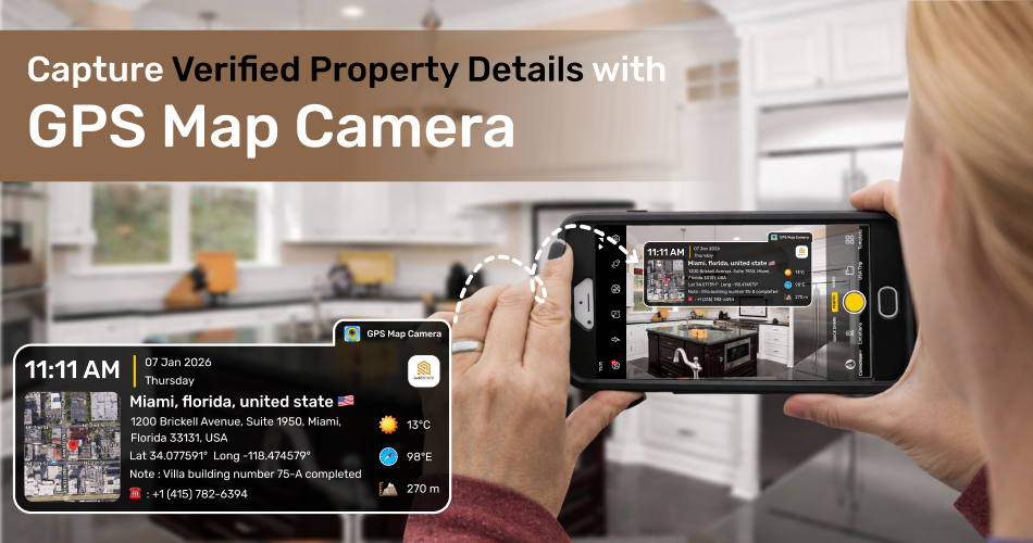
That’s where the GPS Map Camera app comes in. This app lets you take GPS photos with details like location, date, time, coordinates, text, and notes automatically added to each image.
How GPS Map Camera Helps Real Estate Professionals:
➜ Easier Site Visits: Each photo includes the property’s location and a timestamp, so you won’t mix up images from different visits.
➜ Accurate Reporting: The GPS and map details help you create precise reports and keep records easily.
➜ Proof of Work: Every photo shows when and where it was taken, providing solid evidence for clients and managers.
➜ Track Property Updates: Geotagged photos let you compare changes at a site, making it easy to monitor progress or renovations.
➜ Enhance Client Trust: GPS-stamped photos make your reports look professional, boosting client confidence in your work.
The GPS Map Camera makes real estate tasks easier, more organized, and professional.
Work Report – Document & Share Property Visits Easily
Create polished reports from your geotagged property photos with just a few taps. This feature keeps your site visits organized and easy to present.
Key Highlights:
★ Select Photos: Pick only the images you want in your report.
★ Add Details: Include your company logo, name, title, supervisor, reporter name, project name, and remarks.
★ Instant Sharing: Export as a PDF or share directly with clients or your team.
★ Track Reports: Know exactly where each report has been sent.
Why It’s Useful:
Turn your photos into ready-to-share reports that save time and build client trust. In real estate, accuracy and presentation matter. The GPS Map Camera app saves time, reduces confusion, and enhances clarity in your work.
Don’t wait—download GPS Map Camera now and turn every property visit into a professional record!