
A simple photo isn’t always enough. At a construction site, people need proof of where and when a photo was taken. For travelers, knowing the exact spot of a stunning view is key. Without this info, even the best photos lose their story.
Today, people take photos with a purpose. That’s why many choose GPS Map Camera over regular phone cameras. This app captures important details like location, map, coordinates, date, and time. Your pictures aren’t just memories; they’re proof of where you were and what you did.
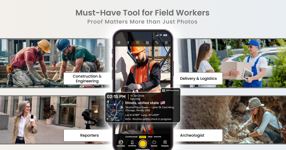
See how GPS Map Camera helps field workers.
➤ Construction & engineering workers: GPS Map Camera lets field and construction teams carry built-in location and time details, making work records reliable and easy to trust.
➤ Reporters: Photos must carry verified information. GPS and time-stamped images provide proof of where and when events happened. This helps maintain trust and credibility.
➤ Archaeologists: Every excavation photo includes exact location, date, and time details.This ensures discoveries are easy to verify, accurately documented, and reliable for future research and reports.
➤ Delivery & Logistics Staff: A stamped photo serves as proof of delivery. The GPS location confirms the parcel arrived at the right address on time.
Key Features That Make the GPS Map Camera Useful:
➞ Add Text or Notes for context
➞ Manual Location Selection for precise documentation
➞ File Name Customization for easy sorting
➞ Auto Folder Saving to keep photos organized
➞ Weather & Compass Stamps for real-world conditions
➞ Person Name Tagging for accountability
➞ Location Sharing for quick updates
Next time you snap a photo, make it meaningful. Don’t just capture a moment—capture the truth behind it. With GPS Map Camera, every image shows where you were, what you did, and when it happened.
Download GPS Map Camera today and see how one click can transform how you capture your world.